|
Thorsborne Trail or East Coast Trail
(3 – 7 day Trek)
The Thorsborne Trail (commonly known as the East Coast trail) is reputedly one of the world’s best backpacking adventures. This 32km trail winds its way along the eastern edge of the magnificent island in the shadow of the rugged Mt. Bowen.
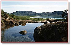
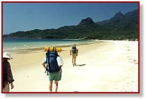 It snakes its way through a tropical wilderness, along spectacular ocean beaches and crosses numerous crystal clear mountain streams. Camp sites are on beautiful beaches, beside fresh water streams or near magnificent mountain stream waterfalls with great safe freshwater, swimming. From Ramsay Bay in the north to George Point on the southern extremity of the island, this walk is a must for those wanting to experience all of the magnificent splendour and isolation this unique island has to offer. It snakes its way through a tropical wilderness, along spectacular ocean beaches and crosses numerous crystal clear mountain streams. Camp sites are on beautiful beaches, beside fresh water streams or near magnificent mountain stream waterfalls with great safe freshwater, swimming. From Ramsay Bay in the north to George Point on the southern extremity of the island, this walk is a must for those wanting to experience all of the magnificent splendour and isolation this unique island has to offer.
The trail is well marked with triangular orange markers on trees at irregular intervals, especially on creek crossings and other places where the trail itself may be indistinct. Rock cairns are also used to help guide walkers along the trail. It is an ungraded trail and is rough with loose stones, slippery creek crossings and, in wet weather, slippery hillsides.
The trail can be walked from either direction with most walkers completing it comfortably in 3 nights (4 days) with the average duration between designated camping sites only 3 – 4 hours. Prevailing weather conditions can have an influence on walking times e.g. slippery surfaces due to rain; heat and humidity.
 While the trail presents seasoned walkers with a challenge, inexperienced and the young at heart adventurers, with sufficient planning, will find the experience extremely rewarding. While the trail presents seasoned walkers with a challenge, inexperienced and the young at heart adventurers, with sufficient planning, will find the experience extremely rewarding.
Walkers must be totally self sufficient. Fuel stoves are required. Abundant fresh water is available at campsites, however, towards the end of the dry season, local knowledge on water availability is required. (QDoE rangers or the ferry operator should be consulted).
Walkers are required to obtain a National Park permit to access this trail. Only 40 walkers are issued with a permit at any one time. Book well ahead, particularly for the Australian winter months or you may not be able to acquire a permit.
PERMITS & NOTES FOR TRAIL WALKERS
Permits:
Call 131304 or visit www.qld.gov.au/camping. Trail maps and notes can also be obtained from this website.
Trail Notes:
The Queensland Department of Environment have comprehensive trail note which are a must for intending walkers. The notes can be obtained from the department’s Cardwell office or from the ferry operator. You will automatically receive a copy of the notes with the purchase of a trekking permit, however it is advisable to obtain a copy beforehand to assist in the planning process.
For information on permits and trail notes call into Queensland Department of Environment Rainforest and Reef Centre CARDWELL Q 4849 AUSTRALIA.
Safety:
Due to the remoteness of the trail and the difficulty of access you are required to organise a definite departure time from the island with the ferry operator before you will be transferred to the trail. This is for your safety. If you do not meet the predetermined pick up time you will be regarded as missing and search procedures will be initiated. This procedure has been instigated as a positive safety feature and generally welcomed by walkers. It should not be considered as a limitation or invasion of your freedom.
Water:
Fresh drinking water is available in the clear mountain streams along the trail. It is mountain spring water and considered safe for drinking without treatment. Towards the end of the “dry season” it may be necessary to seek good water further upstream. The ferry operators will be able to give you current advice on water availability at the different campsites.
Fuel Stoves:
Hinchinbrook Island is managed as a ” fuel stove only ” area to reduce the risk of wildfires and lessen degradation at campsites. Open fires are not allowed.
Native Rats & Insects:
The native mosaic-tailed rat and the white-tailed rat are present at most campsites. To avoid damage to packs, tents and food supplies it is necessary to remove all food from your tent and pack at night and hang it separately. Metal food containers are provided at some sites. These are very pretty and friendly native animals and not an introduced rodent.
It is important to use insect repellent, usually only early in the morning and again late in the evening, to avoid bites from insects such as sand-flies, mosquitoes and marchflies.
Planning your trip:
This is a wilderness area. You need to be self-reliant and self-sufficient.
You will need to:
THE MOUNTAINS
Much of the mountain area is covered with fragile heath vegetation. To protect the unspoiled nature of the mountains and in the interests of safety, access to these areas is restricted. A special permit is required to access these mountains.
Mt. Bowen:
This is the highest peak on the island (1121m) and the most popular with climbers. A very limited number of permits are issued to access this area. On average, first time climbers take 1.5 days to reach the summit. There is no trail up the mountain and climbers must rely on their own navigational skills. In summer it is a very hot climb and the summit is often in cloud. Winter days are much cooler and there is greater probability of the summit being cloud free.
Mt. Straloch:
In December 1942, an American B24 Liberator bomber known as Texas Terror left Townsville for Cape York on the northern tip of Australia with a crew of five and seven passengers aboard. It ran into a severe electrical storm and crashed near the summit of Mt. Straloch. All aboard were killed. Due to the difficult terrain the remains of the wreck have had little disturbance since that fateful day. The climb to the wreck site and back can be achieved in a day in good conditions. Local knowledge is required for the climb. The local ferry operator can assist with this knowledge.
|